|
|
Golden Gate Freeway |
Many people have commented on the lack of a complete freeway system within the San Francisco city limits. As it stands today, there are only two complete freeways through the city: Interstate 80/US 101 from the Bay Bridge approach to the southern city limits and Interstate 280 from 3rd Street south to Daly City and beyond. However, there were a number of plans in the ambitious days of the 1960s to furnish San Francisco with a complete freeway network. Many factors combined to prevent this plan from becoming reality, most notably the severe public outcry against freeway construction in the city with the famous San Francisco "Freeway Revolt," the first and probably only instance of a major city protesting all new freeway construction during this frenetic period of highway construction.
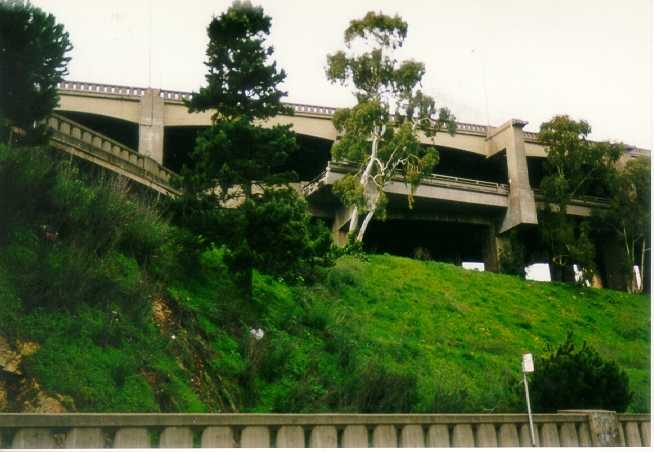
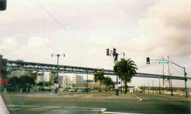
There is much evidence of this proposed freeway network throughout the city. Until its demolition in 1990, the hated Embarcadero Freeway was the most striking example of this interurban freeway plan. This double-deck freeway ran from the Bay Bridge approach to a point just beyond Broadway, where it ended. However, this freeway stub was the beginning of a much larger plan to build a direct freeway link between the Bay and Golden Gate Bridge. Coined the Golden Gate Freeway, future Interstate 480 would have connected these two bridges while negotiating some very dense urban neighborhoods. This page contains major excerpts from the actual Caltrans summary of proposals for this freeway, "Freeway Studies: Panhandle Parkway and Golden Gate Freeway," released in February 1966 by the (then) California Division of Highways and Public Works.
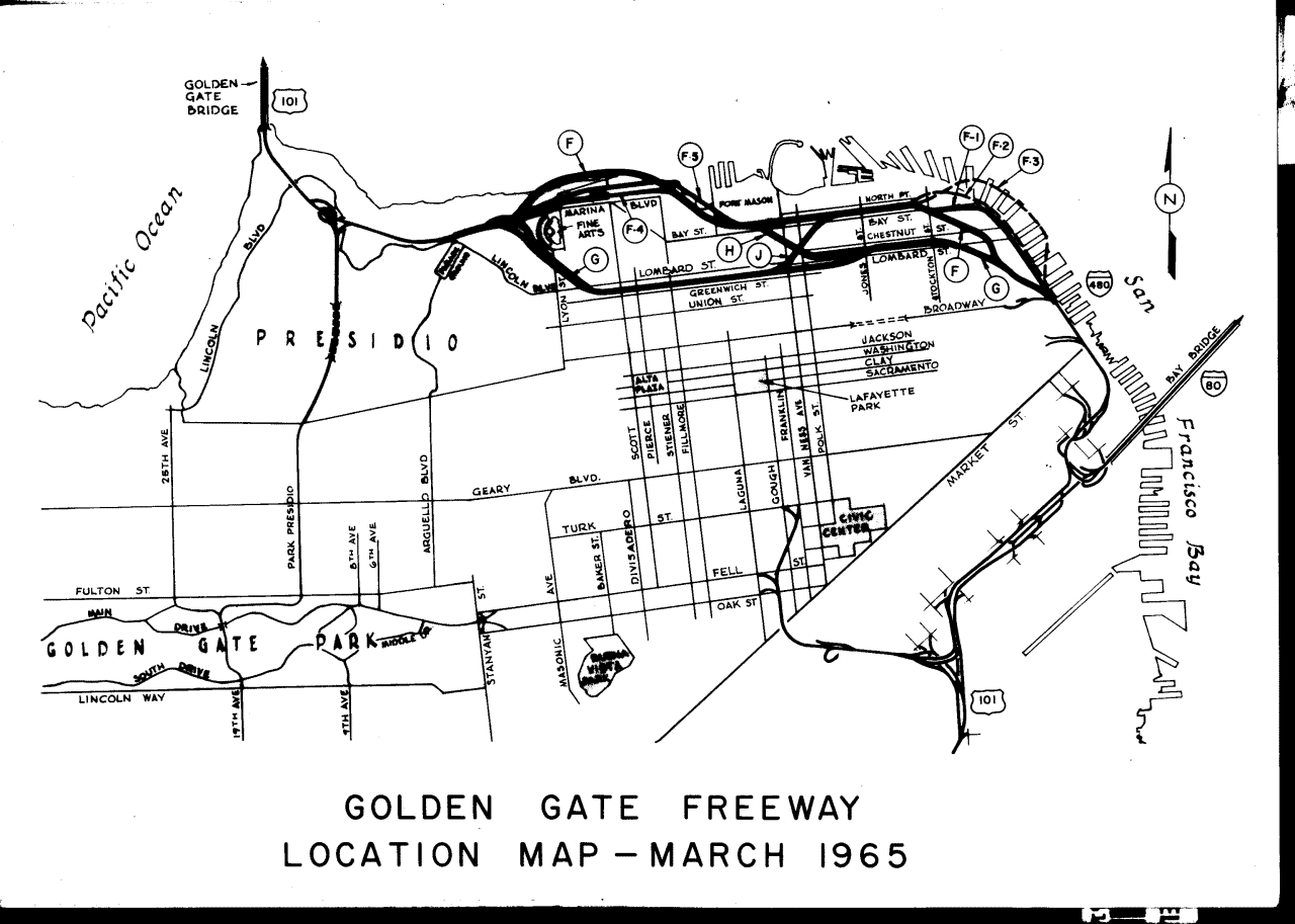
While the actual text of the proposal follows, below are some links of maps and photos taken from the actual proposal:Plans for the Golden Gate Freeway drew from a number of sources during the two year period of public discussion. As directed by the County of San Francisco, the California Highway Commission drew up a number of proposals for the routing of 480 from the (then) termination of the Embarcadero Freeway to the Golden Gate Bridge Approach The Highway Commission eventually settled on option F,F-5 (click here for a map of the original study). In response to this proposal, the SF Board of Supervisors hired out an independent consultant, who proposed an alternative plan consisting of three parallel underground tubes – two six-lane tubes and a third two-lane tube with reversible lanes – each passing under three separate streets. The city also desired an alternative to the current extension of the Embarcadero Freeway that would connect with the Golden Gate Freeway. As a result, the Highway Commission undertook a new study incorporating the earlier State proposal, the Chamber proposal, and variants of each, including an interesting underwater proposal under the Marina and dock facilities. Below are excerpts from the actual supplement to the final study describing routing and type of facility for the proposals relating to the Golden Gate Freeway / Embarcadero Freeway.
Original Highway Commission Proposal & Chamber Alternative
In response to…another resolution passed by the San Francisco Board of Supervisors, studies for location of Route 480, the Golden Gate Freeway, were begun early in 1964. The studies were completed early in 1965 and formally presented to the Board March 8, 1965.
Public map displays were held later in March and a public hearing was held April 9, 1965. Information gathered at this hearing formed the basis for the State Highway Engineer’s recommendation that Plan F, F-5 be adopted by the California Highway Commission as the location for Route 480. This alternative skirts the easterly and northerly faces of Telegraph Hill, then lies between Bay and North Point Streets until it reaches Fort Mason. It crosses the southwest corner of the new Gashouse Cove Yacht Harbor, veers westerly outside the Marina Green, and connects to the Golden Gate Bridge approach with a below-ground-level interchange.
The joint Transportation and Planning and Development Committee of the Board held several public hearings on the project. This resulted in passage of Board Resolution No. 475-65, which reject the state plan and recommended a plan submitted by the San Francisco Chamber of Commerce. The Chamber plan utilizes three tubes passing under Bay, North Point, and Beach Streets, which join together at Fort Mason, pass under Marina Boulevard and join with the approaches to the Golden Gate Bridge in the Presidio.
The current restudy is an extension of earlier planning by putting all proposals under the careful scrutiny of the City, the State, and several teams of consultants in an effort to overcome objections to freeways in these corridors.
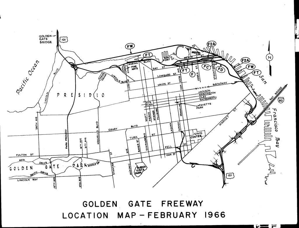
Second Highway Commission Study
The second study offered by the Highway Commission incorporated and compared both the original Highway Commission proposal, the Chamber proposal, and various others. The original proposal was designated as F,F-5. The following are additional alternatives based on the Chamber and other proposals. Below are actual excerpts. Subtitles are mine.
Alternative FT: Chamber Plan
Investigate the feasibility of the plan described in Board of Supervisor’ Resolution No. 475-65 excepting provision 3 thereof relating to phasing out of "the Embarcadero Freeway." This plan is designated as Alternative FT.
FT drops to a depressed section along the Embarcardero at a 5% grade. As it reaches Francisco Street it divides into three tubes, one each passing under Bay, North Point, and Beach Streets. The tunnels under Bay and Beach Streets are three-lane, one-directional freeway sections. The tunnel under North Point Street is two-lane and the direction of travel is reversible, to accommodate peak-hour traffic. The roadways recombine into a conventional depressed freeway section in Fort Mason, pass through the southwest corner of the Gashouse Cove Yacht Harbor and under Marina Blvd. In a cut-and-cover tunnel. Connection to the Golden Gate Bridge Approach is made with a depressed interchange.
The plan as developed by the San Francisco Chamber of Commerce also would eliminate access to the dwellings along Marina Blvd during construction. However, the plan can be modified to conform to any other alternative west of Van Ness Avenue which would eliminate this problem
This plan is the same as that described in the Board’s Resolution No. 475-65 except that an interchange is provided near Columbus Avenue. The Study Committee has concluded that an interchange at this location is necessary to provide acceptable traffic service.
The estimated cost of this alternative is $311.9 million (construction 232.1 million, R/W $79.8 million). Vaulation of property permanently removed from city tax roles is assessed at $0.5 million.
Between the Embarcadero and Van Ness Avenue the street width building face to building face is 68 feet. Width required for the tunnel sections under Bay and Beach Streets is a minimum of 53 feet, which allows a maximum of only 7.5 feet on each side for utility relocation and working space. It has been suggested by the developers of this plan that the "Milan Process" of construction be used. This consists of of trenching the tunnel side walls to full depth and holding the hole open with Bentonite slurry. Reinforcing is placed in the trench and the mud is displaced by concrete. A top beam and slab is then poured and finally the material is excavated from within the structure and the remaining horizontal slabs are poured.
Two other more conventional methods of construction also have been considered. With the first method, drilled hole, cast-in-place piles are poured at close intervals to support the side walls, and transverse beams are placed at ground level to connect pairs of piles and support a surface roadway. The material enclosed by the piles and beams is then removed. The side wall space between piles and the horizontal slabs are then poured to complete the structure.
The third method involves driving sheet piling, excavating the material from within the piling, then pouring the base slab, vertical walls, and the remaining horizontal slabs.
Two advantages cited for use of the "Milan Process" are that time of construction is relatively short and that the surface roadway can be replaced in service quickly.
Ground water conditions are so adverse throughout the construction area that it is doubted that either the "Milan Process" or the drilled hole, cast-in-place pile method can be successfully applied.
This study is based on use of the sheet piling method. Since the sheet piling must be driven very close to the face of the building, vibration may cause some structural damage and the noise level will be high.
An additional problem caused by construction within these streets is that access for fire protection services is severely impaired during construction within any block. This could create a potentially disastrous fire hazard. Also danger of vandalism to the evacuated buildings would be very great.
Because of problems inherent in the construction method, narrow side clearances and the probability that domestic utility service cannot be maintained, it is assumed that residents must be temporarily relocated. This factor plus potential structural damage tend to make right-of-way costs high for this alternative. The apparent low assessed valuation the fact that 247 of the 289 parcels affected can be returned to the tax roles after construction is completed.
Traffic problems created, if this alignment is constructed, take two forms. During construction the only three through streets in this area would be unusable as major traffic carriers. Vehicles needing to use the corridor during peak hours would create almost intolerable traffic congestion since construction of each of the tunnels must occur simultaneously to meet Interstate program deadlines.
Traffic predictions indicate that the three-lane tube functioning in the direction opposite peak hour travel would be operating near or at critical capacity.
In addition, a proposal was made to consider two four-lane tunnels to be located under Bay and North Point Streets. A detailed study of this possibility has not been made because there is only 68 feet between building faces and, since each tunnel is a minimum of 65 feet wide, it is not practical to construct by conventional methods without permanent acquisition of rights of way. While this plan would overcome the traffic deficiencies inherent in the three-tube plan, it would retain all the worst elements of disruption inherent in the three-tube plan.
Alternative F-2-A: Modification of Original Plan East of Chamber Plan
[note: Alternative F-2 was on the original Highway Commission Study]
Investigate an alternative northeasterly of the North Point Sewage Plant. This plan is a modification of Alternative F-2 and is designated as Alternative F-2-A.
F-2-A drops to a depressed section along the Embarcadero at a 5% grade. It passes east of the North Point Sewage Treatment Plant, then swings west around the plant between North Point and Beach streets. Alternative F-2-A remains between these streets to near Mason Street where it veers southerly and conforms to Alternative F near Jones Street.
F-2-A generally is west of the Embarcadero and does not require modification of San Francisco Port Authority piers.
The estimated cost of this alternative is $102.6 million (construction $70.3 million, R/W $32.3 million). Acquisition of 110 improvements, assessed at $2.3 million would be required.
The primary advantages of this plan are that it avoids damage to the Baker development of the former Simmons Mattress Company property and does not cut diagonally across the area immediately north of the existing Broadway ramps. Also, the plan is compatible with existing water front activities yet permits freedom of choice for future water front improvement, since the freeway is partially or completely covered from northeast of Lombard Street to east of Grant Street.
The chief disadvantage is that access between that area east of Telegraph Hill and the Embarcadero is restricted from Vallejo to Lombard Streets, as the freeway transitions from an elevated to a depressed gradeline.
Alternative FC & FD: Modification of Original Plan East of Chamber Plan
Investigate a new depressed design for the F Line east of Columbus Avenue to provide for more efficient use of air rights. Two design variations of Alternative F (east) have been developed and are designated as Alternatives FC and FD.
FC follows the alignment of F (east) utilizing independent roadways for each direction of travel, with one roadway in a depressed section and the other on a ground-level viaduct directly above. The profile for the top level is approx. 22 feet lower than for Alternative F (east) and would allow more efficient joint use of rights of way than F[Note: this leads me to believe that the original 1965 proposal F was to be a double deck structure like the Embarcadero Fwy].
The estimated cost of this alternative is $108.1 million (construction $60.3 million, R/W $47.8 million). Acquisition of 134 improvements, assessed at $2.5 million would be required.
FD also follows the alignment of F (east) but uses a side-by-side depressed freeway section north and west of Sansome Street.
The estimated cost of this alternative is $117.3 million (construction $63.8 million, R/W $53.5 million). Acquisition of 154 improvements, assessed at $3.4 million would be required.
While this alternative would require more right of way than either F or FC, it would allow the most efficient development of the joint-use concept.
Both FC and FD reduce visual impact from Telegraph Hill, especially if possible joint use of air space is exploited.
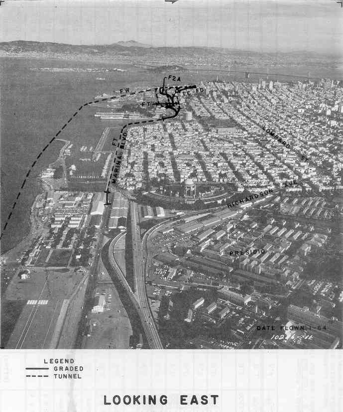
Alternative FW: Underwater Plan
Investigate the general merits of the Aquatic Freeway plan.
The General Merits of the Aquatic Freeway plan suggested by Design Consultants, Inc., a private firm, have investigated and the plan is designated as Alternative FW.
FW follows the alignment of Alternative F-2-A to near the Sewage Treatment Plant. It remains just west of the Embarcadero and enters the water. It passes under pier 45 and passes outboard of the Municipal Pier and the Marina Yacht Harbor jetty in a subaqeous tube. It emerges near Crissy Field in the Presidio and conforms to the Golden Gate Bridge approach near the Route 280/480 junction.
The plan suggested by Design Consultants, Inc., utilizes a double-deck tube with the top of the structure above the water surface except for where access to boat moorage areas is necessary. Because of the limited distances between these areas, the proposed rolling profile could not be achieved in a satisfactory manner. When the profile was worked out in detail it was found that only 1000 feet of the tube could be above water level east of the Marina Yacht Harbor entrance. Approximate 1500 feet of the tube would be less than fifteen feet below the surface in this area. The invisibility of the structure as it transitions above and below the surface, coupled with the short exposed section, would create a serious hazard to all boats and ships using the area.
West of the Marina Yacht Harbor entrance the top of the double-decked tube could be brought above the water surface; however this would create several difficult construction problems. If the structure is above the water surface, it essentially will become a sea wall. It will be exposed to high velocity tidal currents which would cause a heavy overturning moment. The foundation for the structure would have to be specially designed to resist this action. The structure also would be vulnerable to boats or ships cast adrift in the area. Great difficulty probably would be experienced in floating the high-sided structure into place in the face of these currents and the settling it on its foundation.
For the above reasons, the study developed by the State holds the top of the structure below the sea floor through most of its length. A side-by-side section is used is used to minimize the depth of dredging required to place the structure and to minimize the effects of the very high velocity currents in the area.
Interchanges are provided only at the Route 280/480 junction and near Broadway. The State does not find it practical to provide interchange service comparable to the other alternatives studied. The costs to provide this local service would be very high because of the difficulty in constructing underwater interchanges and long approach tunnels. Relatively few city residents would use the intermediate interchanges because of the added circuitry of their trips. The plan, therefore, primarily would serve Marin County residents.
This plan, relative to other alternatives investigated, would not offer traffic relief and resulting freedom of movement on the city streets in the corridor. For the costs involved, more than $250 million, the plan does not offer the traffic service that should be expected from an expenditure of this magnitude.
If the interchanges are provided, two additional freeway lanes would be required and the costs would increase out of proportion to the additional service gained.
This plan utilizes a continuous tunnel approximately 3.4 miles in length. This long, underwater tunnel location probably will constitute a severe psychological barrier to many persons who might otherwise use this route.
This type of construction also would accrue very heavy costs for maintenance and surveillance. Access to the sites of accidents and or fires would be very difficult.
The only advantages of this plan are that it requires very little right of way and it is out of public view through most of its length.
Back to DLK's Highway Page